Internet service provider, Quickline worked with emapsite, a location services platform, to connect business and communities to super-fast broadband.
Challenge
Quickline wanted potential customers to find out quickly and easily whether they can connect successfully to its network simply by entering their postcode on its website.
Solution
The web services model built by emapsite establishes whether there is a clear line for the signal from Quickline’s mast infrastructure using the property address, building heights, terrain and surface clutter. Detailed geographic data was critical to the viability and success of the model.
The Quickline website asks customers to enter their postcode, which calls the emapsite address API. This is based on the latest OS AddressBase data update, providing a list of addressable options and height of that property using the building height attribute (BHA) from OS MasterMap.
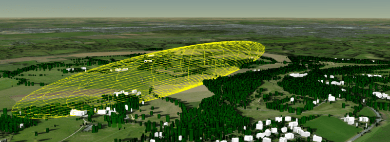
emapsite then runs line-of-sight (LoS) analysis at address level using an accurate property height to the 3 nearest mobile masts and known heights of the satellite equipment. This unique LoS is run through the radio Fresnel zone against detailed OS Terrain 5 data and surface clutter derived from buildings, structures, vegetation, and trees including Bluesky’s National Tree Map.
The response to the user is a simple ‘we can connect you to super-fast broadband’, ‘we can’t connect you yet but hope to soon’, or ‘we may be able to connect you and will survey your site’. These calculations are complex algorithms that are run in parallel on multiple GPUs to achieve sub-second responses. The service is available as an API that can be tailored to fit a business workflow and requirements.
Benefits
Significant cost and time savings on surveyor site visits
Previously each enquiry would require a surveyor site visit at a cost of £150, sometime with the need to stand on a ladder with binoculars to locate a mobile mast in a 360 arc. The net savings in costs per connection for Quickline are enormous and still to be properly determined.
Targeted marketing and improved service to potential customers
The integration of geographic data services has been transformational to Quickline, not only with the ability to inform users instantaneously whether they can connect or not, but in effective planning of marketing to suitable customers.
More effective network planning and siting of masts
The solution also support network planning by running point to multi-point scenarios that identify the best positions for new mobile masts to connect the widest potential audience in poorly connected areas.